
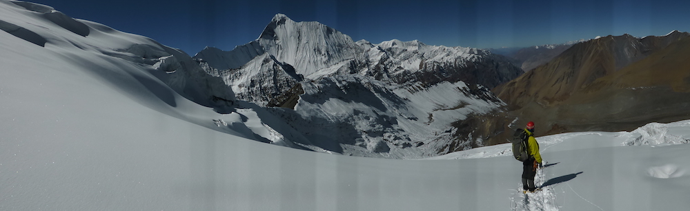
La traversée du Mukot Himal ne c’est pas faite sans une préparation préalable importante.
Il a d’abord été nécessaire d’inscrire ce sommet sur la liste officielle des sommets autorisés par le ministère du tourisme. Ce qui a été fait début août 2013 puis mis en oeuvre en 2015.
L’objectif était de créer une nouvelle porte d’accès au Dolpo et de promouvoir le versant Est du Dhaulagiri et la vallée de Mu que nous avions traversée avec Chhotemba en 2002 de retour d’une expé à la Putha Hiunchuli.
En 2015, KE (un TO Anglais), remarque le Mukot Himal comme clef d’un nouveau programme au Dolpo et réussi à organiser deux groupes. C’est le début de la visibilité de ce sommet qui sera forcément repris par les autres agences internationales.
Il reste maintenant à réussir la première traversée du sommet et surtout à en faire la promotion dans nos médias spécialisé et sur le web en Français et en Anglais.
Plus concrètement, en fin de printemps 2016, après l’Himlung, Bishal et Bahadur sont partis tous les deux pour Dorpathan pour vérifier jusqu’où montait les jeeps. Ils sont ensuite rentrés par Mu et Sangda.
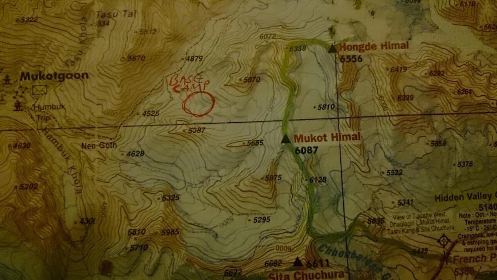
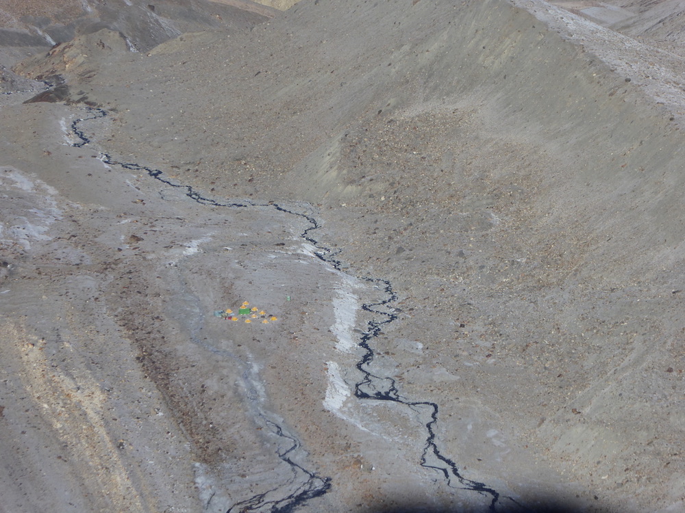
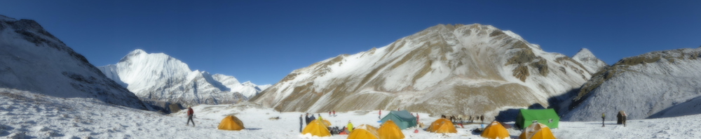
Pendant ce temps, Rajan et Dhan sont partis versant Hidden Valley pour bien identifier l’emplacement du camp de base.
C’est la première fois que des népalais de mon équipe partent en reconnaissance seul dans un massif qu’ils ne connaissent pas pour préparer un nouveau projet.
Félicitations…

Puis un contact par mail a pu s’établir avec Mark Aitken qui a fait partie de l’un des groupes de KE de l’ascension versant Dolpo depuis Mu, à l’automne 2015. Mark m’a également envoyé une vidéo de cette première ascension officielle du Mukot Himal
https://www.youtube.com/watch?v=QdsitkGJoLk
Sur internet, il est possible grâce à l’American Alpine Journal de suivre l’exploration de cette région.
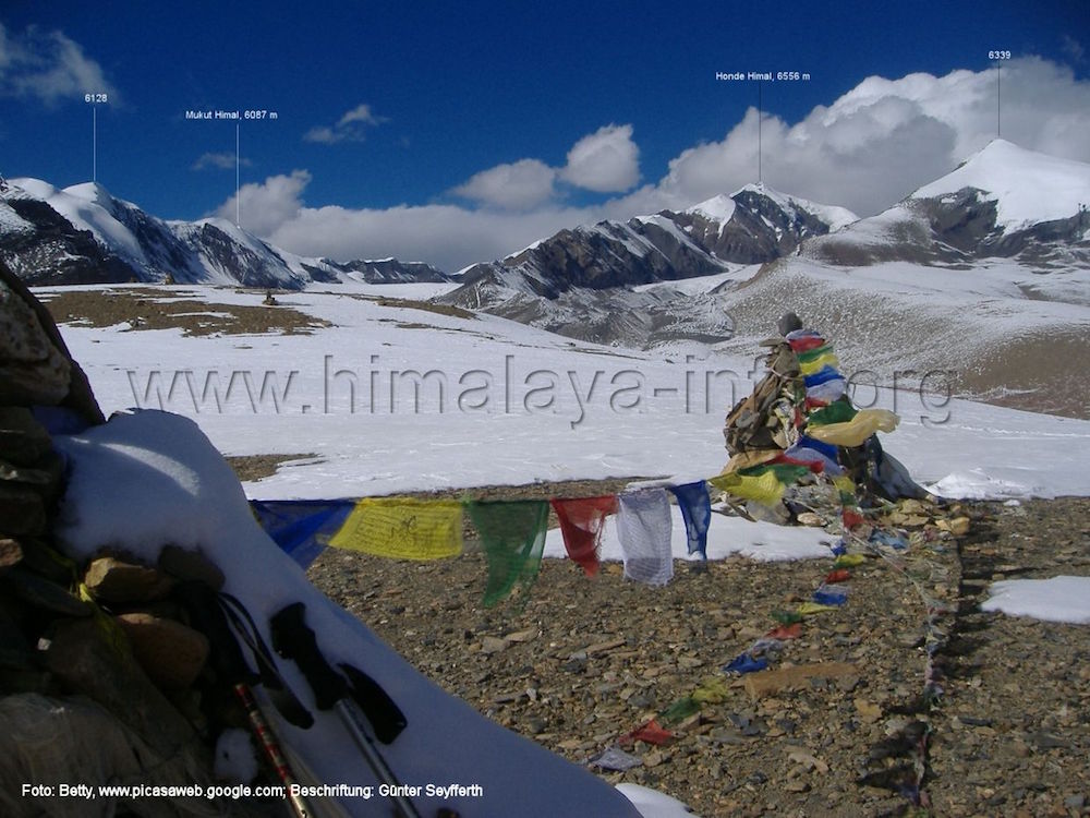
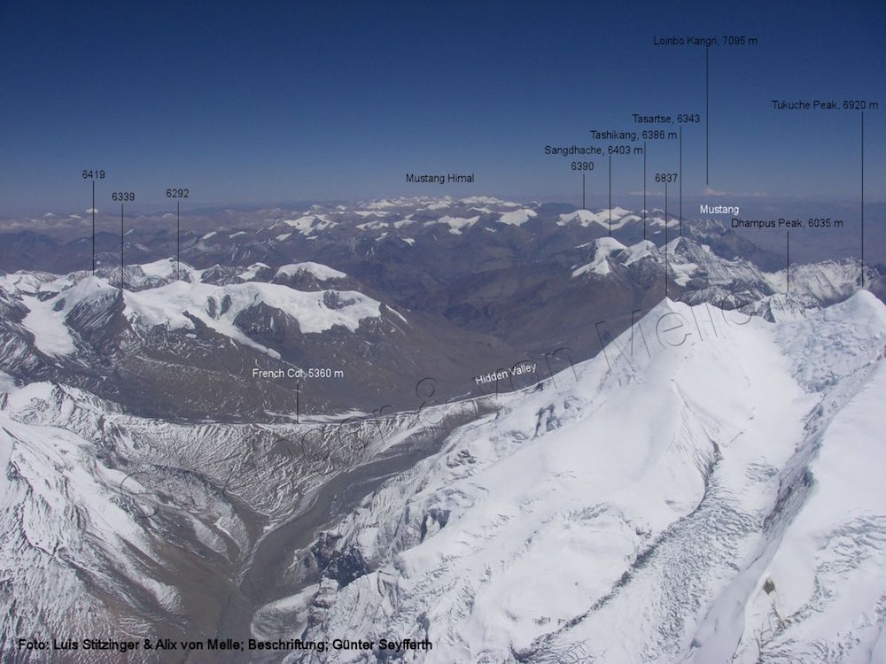
Et un site en allemand indispensable, de Günter Seyfferth, Himalaya-info
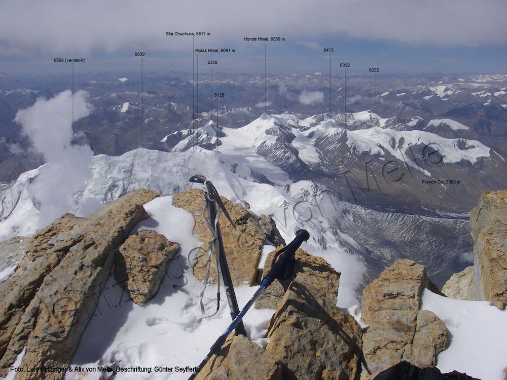
Avec une présentation complète du massif du Dhaulagiri et du Mukut Himal :
http://www.himalaya-info.org/dhampus-pass.htm
Un article dans l’AAJ en 2015 sur les nouveau sommet de l’Ouest.
Western Nepal : news peaks and exploratory opportunities, by Paulo Grobel
http://publications.americanalpineclub.org/articles/13201213179/Western-Nepal-New-Peaks-and-Exploratory-Opportunities
Mukut Himal and Kanjiroba Himal.
The 1959 American Himalayan Expedition returned to Kathmandu on November 30, after a successful trip of two-and-a-half months into the area north and west of Dhaulagiri, in central Western Nepal.
The group consisted of four American climbers, John Humphreys, Caspar Cronk, Dr. Fred Dunn and John Noxon; four Sherpas (under Sirdar Ang Dawa) ; and a Nepali liaison officer, Manik Tuladhar.
The party met its group of Sherpas at the Nautanwa railhead on the Indian border and walked for three weeks across Nepal to reach its area of operations, using successively porters, mules and yaks for transport. The route mainly followed the course of the Kali Gandaki river, which cuts through the main range between Dhaulagiri and Annapurna, until it branched off to the west about 15 miles south of the Tibetan border. We crossed three high passes (the highest, 18,600 feet) with a yak train and set up base of operations in the heart of the Mukut Himal, just north of Dhaulagiri II, on October 14. After the end of the heavy monsoon storms on October 7, the weather was with very few exceptions uniformly clear; a total of about 70 hours of precipitation were recorded during the next 63 days.
From this first Base Camp, the party made a concerted effort to climb the highest Mukut Himal peak, about 21,900 feet in height, in the process climbing a subsidiary peak of about 20,300 feet. The final attempt on the higher summit was made by Dunn, Noxon and Cronk, while I was recovering below from a short bout with pneumonia. They were not successful because of cornices encountered several hundred feet below the top in the midst of a snowstorm. Some expedition scientific work was also begun while in this area, in the form of preliminary theodolite triangulation, a geological collection and a small high-altitude botanical collection.
http://publications.americanalpineclub.org/articles/12196015400/Asia-Nepal-Mukut-Himal-and-Kanjiroba-Himal
Japanese Exploration in Nepal
I. EXPLORATION OF THE TORBO DISTRICT, EAST OF KANJIROBA HIMAL
Jiro Kawakita
Our party of eight members, J. Kawakita, leader, M. Ogata, K. Nishoika, O. Namikawa, Y. Sonehara, R. Taka- yama, S. Iijima and S. Omori, had two aims: one was scientific, especially anthropological, and the other was climbing in the Kanjiroba Himal. The party left Pokhara on July 11, 1958 and reached Tsarka (Chharkabhot- gaon) on August 4, via Tukucha. On our journey we were much helped by the gentlemen of the Serchan families and others of the Takali people of Tukucha. The influence of the monsoon rain was fairly strong until the middle of August, even on the northern side of the Dhaulagiri Himal. After that, until the end of September, fine and rainy weather alternated in a cycle of several days. We were tortured by the flooded torrent three times between Tukucha and Tsarka. In the upper Keha Lungpa river valley, we found that the so-called « Hidden Valley” flowed out from a tremendous fissure between giant cliffs. No climber could overcome those cliffs from downstream, and therefore « Hidden Valley” remained literally hidden.
Between August 20 and September 5 the mountaineering party, composed of six members, made a training trip to the Mukut Himal and came back to Tsarka by way of Mu (Mukut) and the main stream of the Barbung Khola. In the Mukut Himal (called Mu Khan by the natives) we climbed four minor peaks on the eastern side of the Mu La (Mukut Pass), the highest of which was only 6100 m. (20,013 feet) . The highest peak of the Mukut Himal seemed to lie in the midst of the « Hidden Valley” but, hindered by clouds, we could peep from the summits only down a part of the valley.
The area is traditionally called Torbo and includes the villages of Tsarka, Tarap, Hsyimen, Phijer, She Gompa, and Phopa. Tsarka was the highest settled village with spring barley fields at an altitude of about 13,800 feet. We chose Tsarka and secondarily Phopa and Phijer as the objects of intensive study of Tibetan community life.
The Barbung Khola below the junction of the East Churen Khola could not be waded without a portable boat, even in the dry season.
Four climbers started from Tsarka for the Kanjiroba Himal on September 8. They reached Phijer after a week’s travel. As a route into the mountains was not discovered, they marched further to Phopa. Yaks were not available beyond Phijer and every village of Torbo was too small to supply sufficient coolies and food. Phopa, a poor and decaying village, was to be abandoned within three years, for the source of irrigation water is gradually becoming exhausted, possibly because of the extinction of some concealed underground ice source. From Phopa, a reconnaissance party started for the Kanjiroba Himal again but failed to cross the main stream of the Mugu Karnali after a two days’ trip. The road downstream along the river is, according to the villagers, passable only in the winter season. They call the Kanjiroba Himal « Khan Jerowa.” After an exploratory eight day tour toward the west, they came back to Phopa. The approach to the Kanjiroba Himal from the northeastern side seemed almost hopelessly hindered by deep gorges and torrents, and the northeastern slopes of the mountains were quite steep. They chose another route on their return trip to Tsarka because an epidemic was raging in Tarap and Hsyimen. All the members joined again in Tukucha on November 1.
http://publications.americanalpineclub.org/articles/12196006600/Japanese-Exploration-in-Nepal
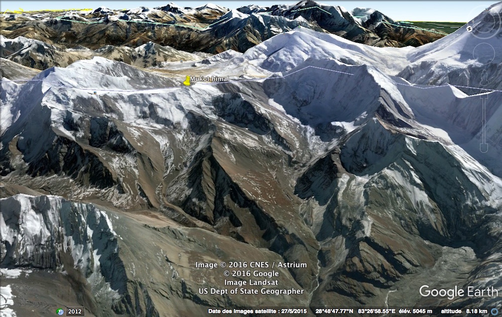
Mukot Himal, first official ascent.
Added to the permitted list in 2014, Mukot Himal (6,087m) is located in a remote and wild corner of Nepal, nestled into the flank of the rarely seen but phenomenal Dhaulagiri II. KE Adventure Travel organized three groups to attempt the peak during the autumn.
In mid-October, Kami Sherpa, Mingma Dorje Sherpa, and Gelgin Sherpa equipped most of the 600m route to the top with fixed rope. On October 17, Mark Aitken, Sian Beaty, Alexander Duhault, and Mark Soares, from a Canadian-U.K. group led by Adrian Sommers, reached the summit. The Sherpa team and foreign climbers approached from the northwest to a col on the north ridge (45–50° below the col) and then followed the ridge (30–35°) to the summit, for an overall grade of PD+. The second team was led by Tom Richardson (U.K.). Pasang Sherpa, Dorji Sherpa, Richardson and his wife, Janet James, Jeremy and Helen Anson, Alan Johnson, Eric Larson (USA), and Karyn Maltby followed the same route and reached the summit in six hours from advanced base, benefiting from the ropes used by the previous team. Although these were the first “official” ascents, this peak was most likely first climbed in 1967. A little later a third group, another large Canadian-U.K. team led by Val Pitkethly, arrived at base camp in time to suffer 48 hours of continuous snowfall and were unable to attempt the mountain.
Rodolphe Popier, France, and Tom Richardson, Alpine Club, U.K.
http://publications.americanalpineclub.org/articles/13201213860/Mukot-Himal-First-Official-Ascent
Mukut Himal and Churen Himal. 1961 ?
The Nihon University Expedition started from Pokhara on April 11 for the northwest of Dhaulagiri. We planned for about 100 days, using successively porters, mules and yaks for transport. The party consisted of four members, S. Ishizaka, Z. Hirayama, Y. Kumagai and T. Miyahara, five Sherpas under the sirdar Ang Temba, and a Nepali liaison officer, B. Roka. We arrived in Tukuche after one week. Until April 19 we acclimatized at Dampus Pass and Hidden Valley and climbed Dampus Peak (19,935 feet) ; then we made three more camps near the Mukut Himal. Hirayama, Miyahara and I and two Sherpas, Ang Temba and Ang Dawa, reached the highest point of the Mukut Himal, Hangde (6600 meters or 21,654 feet by our calculations) on May 8. As we returned, we climbed three other peaks of 6000 meters (one of them a second ascent for it had been climbed by the American expedition in 1959). (See AAJ 1961, 12:2, pp. 249–262. This
last peak is “Tongu Peak” ca. 20,500 feet.—Editor.) The two first ascents were of P6265 (20,554 feet), three miles east of Tongu on May 10 by Miyahara and me and of P6025 (19,767 feet), one mile northeast of Dampus Peak, on May 14 by Hirayama, Kumagai and Ang Dawa. On May 15 we came back to Tukuche and prepared to follow the coarse of the Kali Gandaki and Kehalungpa rivers. We reached the high pass (Mu La, 18,537 feet) but found the snow so deep that even the yaks could not cross. That day, May 26, we left all our baggage there and crossed to Mukutgaon to make arrangements for new yaks. After five days we reached Kakkotgaon in the Barbung Khola to climb in the Churen Himal. After three days we set up an advance camp at 15,000 feet. We made two more camps but came down after reconnaissance because of monsoon storms and shortage of time. There Hirayama and Ang Temba climbed Kantokal (ca. 21,325 feet), just north of Putha Hiunchuli on June 7. The return journey began on June 10. We crossed the Jang-La-Bhanjyang pass (14,272 feet) and reached Pokhara via Dhorpatan on July 1.
From Shojiro Ishizaka, Nihon University Alpine Club
IN AAJ, VOL 13, 1963
http://publications.americanalpineclub.org/articles/12196352002/Asia-Nepal-Mukut-Himal-and-Churen-Himal
Au sujet des glaciers du Mukot Himal
« Changes in glaciers in Hidden Valley, Mukut Himal, from 1974 to 1994 »
In Journal of Glaciology Vol 43, N° 145, 1997
https://www.igsoc.org/journal/43/145/igs_journal_vol43_issue145_pg583-588.pdf
Paulo, le 19 septembre 2011
La veille du départ pour la traversée du Mukot Himal